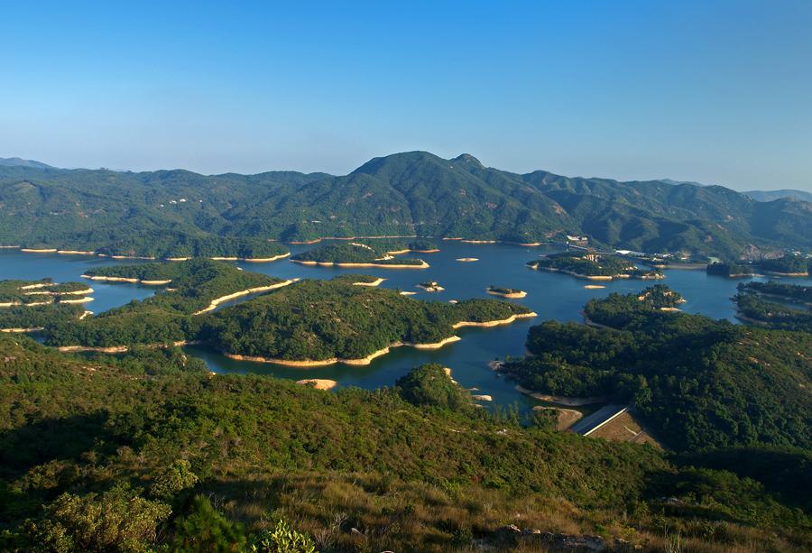
Tai Lam Chung Reservoir was built between 1952 and 1957 in Tai Lam Country Park. To strengthen the structure, the reservoir is designated as the afforested area, and Maclehose Trail Stage 10 passes the north side of the reservoir.
Therefore, it is not only a cool place to visit in summer, but also a very popular scenic spot to see maple in later autumn.
Before the reservoir was filled up, there were many hills inside. Nowadays, those hills have become dozens of small islands in the reservoir, which makes it look like the Thousand Island Lake (Qiandao Lake) in Zhejiang Province in China.
—
How to Get There:
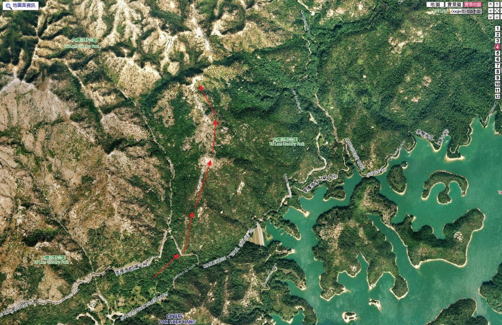
You can follow Maclehose Trail Stage 10 to visit Tai Lam Chung Reservoir. If you want to take a picture of the “thousand islands” view, you need to climb uphill when you are near the reservoir.
—
Chinese Translation:
Tai Lam Chung Reservoir: 大欖涌水塘
Tai Lam Country Park: 大欖郊野公園
Qiandao Lake: 千島湖


[…] Maclehose Trail Stage 10 and in Tai Lam Country Park (大欖郊野公園), it is the best place to see maple (or people usually call it “red […]
How to go on this to take picture see the view of the lake pls help thanks
Hi Juliet,
If you follow Maclehose Trail Stage 10, you can see the view when you are passing the reservoir.
What Juliet says, is how to go there when there is no direction within the picture.
Hi it me juliet what is the entrance of hill i go in maple tree passing to the reservoir the end of.my hiking last exit in the bus of bus 43 or bus 43 s but i dont no the way of the uphill u have picture of the hill so i cant passing climb up the hill.pls i.like you picture and i love hiking thaks so much for your imfo
Hi Juliet, the small trail is hard to find. I put a map in the article and hope it is helpful 🙂
Thanks i go back again soon in tai lam country park to find the way up.the.hill thanks so much
Hi Chensong,
Is it possible to walk between the little islands?
cheers
Hi Tony, nope. Cannot walk between the islands.
Hello,
Are there any BBQ pits near the reservoir? Thanks
Hi, yes, there are lots of BBQ areas in the country parks. There must be a few around the reservoir.
Is the path uphill really a path that one can walk on? or is it more like climbing along the hillside. Another website showed the direction but the path looks like one would have to be on all 4 going up.
Hi Jane, the top of the hill is around 300m. You do not need to reach the top in order to view the whole reservior.
Do you think there’s any way to go paddling inside the reservoir?
For this reservoir, no 🙂 But you can try Tai Mei Tuk Water Sports Centre and Chong Hing Water Sports Centre.